대표어
대표어
 학술연구정보서비스(KERIS)
권호기사보기
| 기사명 | 저자명 | 페이지 | 원문 | 기사목차 |
|---|
결과 내 검색
동의어 포함
Title Page
Abstract
Contents
ACRONYMS 12
CHAPTER ONE. INTRODUCTION 15
1.1. Background 15
1.2. Problem Statement 17
1.3. Objectives of the Study 18
1.4. Research Questions 18
1.5. Hypothesis 18
1.6. Significancy of the Study 19
1.7. Justification of the Study 19
CHAPTER TWO. LITERATURE REVIEW 21
2.1. Forest Governance 21
2.2. Sustainable Forest Management (SFM) 24
2.3. Policy Process Implementation 25
2.4. Activities for Sustainable Forest Management in Malawi 27
2.5. Remote Sensing 29
2.5.1. Definition of remote sensing 29
2.5.2. Remote Sensing and Electromagnetic Energy 30
2.5.3. Vegetation Cover and Remote Sensing 30
2.6. Previous Studies on Change Detection of Vegetation Cover 31
CHAPTER THREE. MATERIAL AND METHODS 35
3.1. Study Area 35
3.2. Data Collection Methods 36
3.2.1. Satellite Images 36
3.2.2. Selection of Forest Experts for Interviews 36
3.2.3. Review of Secondary Data and Documents 36
3.3. Data Analysis 37
CHAPTER FOUR. RESULTS AND DISCUSSIONS 40
4.1. Introduction to the Findings 40
4.2. Detecting Forest Cover Change 40
4.2.1. Land Cover Map from 2013 Landsat 8 OLI Image 43
4.2.2. Land Cover Map from 2022 Landsat 8 Image 46
4.2.3. Land Cover Change Trend from 2013 to 2022 48
4.2.4. Accuracy Assessment of Land Cover Classes 49
4.3. Forest Policy Gaps 50
4.4. Factors Limiting Effective Policy Implementation 52
4.4.1. Poor Coordination among the Departments 53
4.4.2. Inadequate Capacity among Key Stakeholders of the Forest Sector 53
4.4.3. Inadequate Extension Staff 55
4.4.4. Low Funding on Forestry Development and Research 56
4.4.5. Ineffectiveness of Existing Regulations in Addressing Forest Loss 56
4.5. Policy Recommendations 57
4.5.1. Improve Forest Governance 57
4.5.2. Invest in Forest Based Enterprises 58
4.5.3. Conduct Forest Policy Meetings with Legislatures, Politicians and Local Leaders 59
4.5.4. Provide Incentives to People to Promote Management of Forests 59
CHAPTER FIVE. CONCLUSION AND RECOMMENDATIONS 61
5.1. Conclusion and Recommendations 61
5.2. Recommendations for Future Research 64
BIBIOGRAPHY 65
Appendix 1. Research Interview Questionnaire for Forest Experts Introduction 73
요약 75
Figure 1. Spectral Reflectance Curves for Vegetation, Soil and Water 30
Figure 2. Location map of the study area 35
Figure 3. 2013 Satellite Image Captured on 2013/10/21 41
Figure 4. 2022 Satellite Image Captured on 2022/10/14 41
Figure 5. Visualized Image for 2013 42
Figure 6. Visualized Image for 2022 43
Figure 7. 2013 Classified Map of Chimaliro Forest Reserve 44
Figure 8. Areas in hectares (ha) of 2013 Land Cover Classes (a) and their percentage (%) (b) 45
Figure 9. 2022 Classsified Map of Chimaliro Forest Reserve 46
Figure 10. Areas in hectares (Ha) of 2022 Land Cover Classes (a) and their Percentages (b) 47
*표시는 필수 입력사항입니다.
| 전화번호 |
|---|
| 기사명 | 저자명 | 페이지 | 원문 | 기사목차 |
|---|
| 번호 | 발행일자 | 권호명 | 제본정보 | 자료실 | 원문 | 신청 페이지 |
|---|
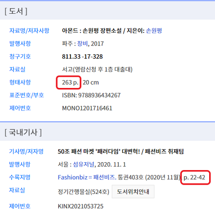
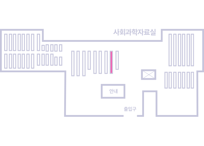
도서위치안내: / 서가번호:
우편복사 목록담기를 완료하였습니다.
*표시는 필수 입력사항입니다.
저장 되었습니다.